Talk:The Lodge
The DM: I've tried everything I can think of or understand in my reading to fix a certain table I'm trying to add to my map files.
- Vafrandir: Which page are you on and what is the goal?
The DM: With this, I'd like the blocks with Map B1 and Map B3 to overlap with East Spitsbergen, so that Lapland is snuggled in the middle.
| A1: Greenland Sea | A2: East Spitsbergen | A3: Jotunheim |
|---|---|---|
| B1: Lofoten | B2: Lapland | B3: Yak'Margug |
I can't seem to make it happen, however.
The DM: By inventing a fake heading, I was able to make this table look like I wanted:
| A1: Greenland Sea | A2: East Spitsbergen | ||
| B18: Iceland | B1: Lofoten | B2: Lapland | |
| C1: North Sea | A2: Baltic | ||
The DM: However, this is a disaster.
| A1: Greenland Sea | A2: East Spitsbergen |
A3: Jotunheim | ||
| B1: Lofoten | B2: Lapland | B3: Yak'Margug | ||
| C1: North Sea | C2: Baltic | C3: Lithuania- Poland |
C4: Upper Volga | |
The DM: I can’t figure out what the column widths have to be to make these work. And if there was a better way to do it ...
Vafrandir: I'll take a look and see what I can figure out. Will each case be different or is there a pattern of overlap for each set of maps?
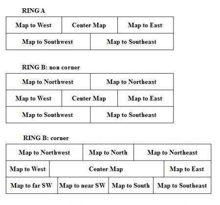
The DM: I’d like these to be consistent on some level. These are the three different forms of the table that will occur. The Lapland table (3rd shown) is goofy because the Lapland map sits at the point where the projection turns 60 degrees. The Lofoten map (2nd shown) will be far more common, as there is no projection turn. The East Spitsbergen map (top shown) only has two levels because there are no maps to the north (unreachable Arctic Ocean).
The DM: I can make some picture versions of the desirable result, if that would help.
Vafrandir: This tricks the table into a 7-column grid, each of 14% width. A2, B1, and B3 are all 3 columns, A1 and A3 are 2, and B2 is 1. How should the C row align with the B row in terms of overlaps?
| A1: Greenland Sea | A2: East Spitsbergen | A3: Jotunheim | ||||
|---|---|---|---|---|---|---|
| B1: Lofoten | B2: Lapland | B3: Yak'Margug | ||||
We can reuse this so that the E Spitsbergen map is consistent.
| A1: Greenland Sea | A2: East Spitsbergen | A3: Jotunheim |
|---|---|---|
| B1: Lofoten | B2: Lapland | B3: Yak'Margug |
| A1: Greenland Sea | A2: East Spitsbergen | ||||
| B18: Iceland | B1: Lofoten | B2: Lapland | |||
| C1: North Sea | A2: Baltic | ||||
Let me see if I can trick the Lapland map as well.
I think for the third form a sketch would be helpful.
The DM: Ideals, but probably impossible:
Vafrandir: How does this look? Took a bit of forcing. This is on a grid of 12, so each (assumed) grid column is about 8% of the whole.
| A1: Greenland Sea | A2: East Spitsbergen |
A3: Jotunheim | |||||||||
| B1: Lofoten | B2: Lapland | B3: Yak'Margug | |||||||||
| C1: North Sea | C2: Baltic | C3: Lithuania- Poland |
C4: Upper Volga | ||||||||
Better than I could do. I'll take it.
